|
Save beauty, made by nature
Contacts:
Address: s. Ust-Koksa, ul. Zapovednaya, 1,
Phones: +7(38848)22-9-46, +7(38848)23-1-43,
E-mail: katunskiy-eco@mail.ru
Address: s. Ust-Koksa, ul. Zapovednaya, 1,
Phones: +7(38848)22-9-46, +7(38848)23-1-43,
E-mail: katunskiy-eco@mail.ru
The Katun highlands
Route length: 20 kilometers over the nature reserve territory
Tour duration: 4 days
Mode of travelling: on horse, on foot, by water
Tour description:
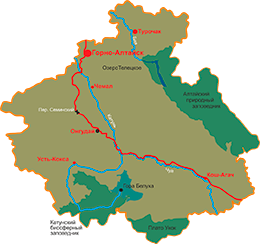
The starting point of this tour is village Katanda at the mouth of the river Kuragan. First the horse trail leads the tourists to the natural boundary Kyrgyz along the Kuragan River, then it goes to lake Emerald (Izumrudnoye) along the Kazinikha River and gets to the cordon by lake Taimeniye and to the mouth of the Ozernaya river. Here the tourists take a motorboat and go by the Katun to Maralovodka village.
The route goes through deciduous and cedar forests, subalpine meadows and stony tundra. It abounds in great varieties of wonderful landscapes. Here one gets an opportunity to watch some wild animals: a maral, a roe deer, a musk deer, a moose and a bear.
The main attractions of this tour are picturesque highland lakes (the Emerald, the Kazinikhinskoye, and the Taimeniye), the Kuragan river canyon and the Kazinikha pass.
Lake Taimeniye is a natural landmark of regional importance and the largest lake in the Ust-Koksa region. It is located at the attitude of 1570 m. There are several minor rivers that originate from the Katun ridge glaciers and snow fields and fall into the Taimeniye. The shoreline of the Taimeniye belongs to the territory of the Katunskiy nature reserve.


